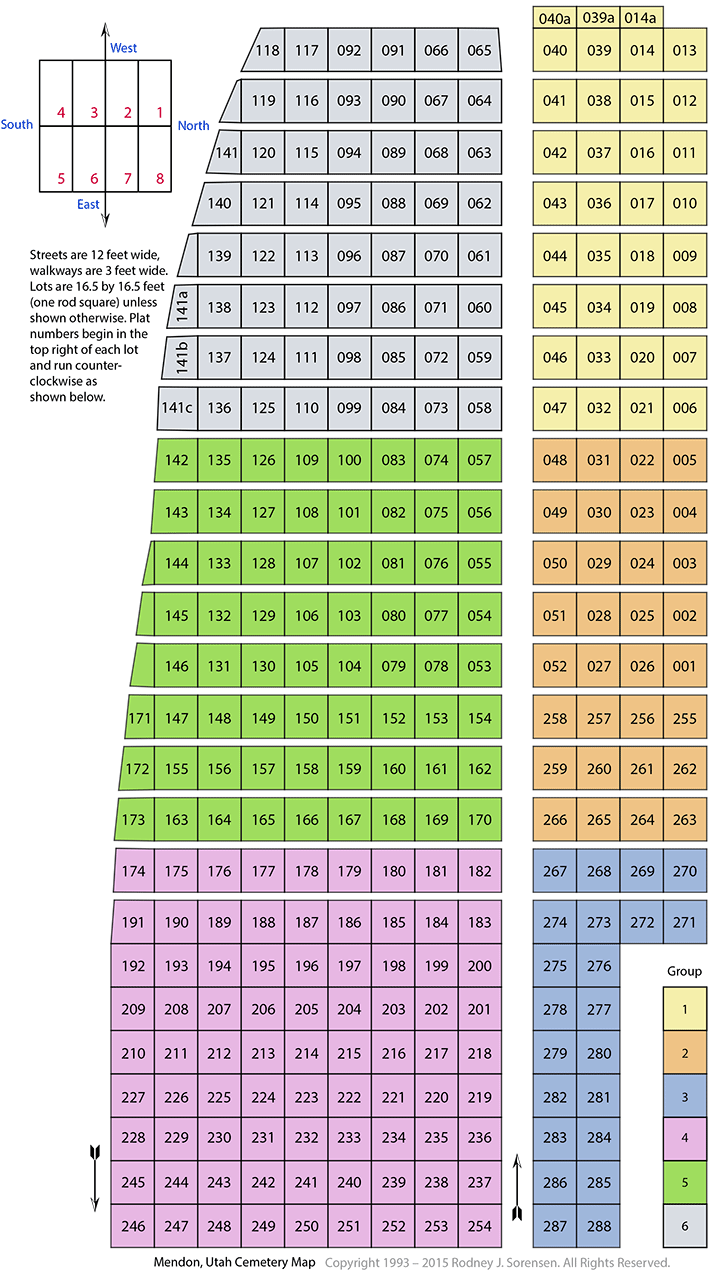
Mendon Cemetery Plat Map
Mendon Cemetery
I drew up this map of the Mendon, Utah Cemetery beginning in the spring of 1993, from my physical lot by lot, plat by plat survey. It took some four years to complete the survey and this map. For many years the cemetery was thought to be more or less square. However as you can see here the cemetery does have a three plot (about fifty feet) taper on the south-west near the top end. Over the years this taper has caused more than a few graves to be located in the wrong place(s). Some interments were not even in the plat lot the family had purchased. When the cemetery was thought to be square, if the sexton pulled his measurements from the South side of the cemetery, well they would be in the wrong place. The cemetery is chained from the Left side of the straight road, along plot numbers 64 to 254.
When I found this problem in my survey, at the time I became the Mendon cemetery Sexton in 1999, I tried to repair the errors with the families affected, as best I could. I bought lots back, sold others and traded some. For the most part this has corrected the impending problems that were just waiting to happen.
I had all of the lots in Group 3 and the lower part of Group 2 renumbered as 255 to 288. The Mendon Cemetery as it is now, and as it is shown, has a unique identifying number for most every lot. Prior the noted groups started over again with plots 1-34. So one needed to know both the group and lot to keep them separated. Now each plot just has its own number, with the only exceptions a few partial lots along the edges of the cemetery.
The old original Mendon Pioneer Cemetery extended from the present west end (minus the 'a' half lots) down to lot 1. There was once a old cedar post, three strand barbwire fence, along the east side of lots 1 to 146. The cemetery carries the same format down to lot 174 to 270 where the lots east of this point no longer have the three foot walk ways between the graves. I am unsure as to why this change was made
But I do know the sexton would not do it. A little wiggle room makes a lot of difference in getting everyone in. When we expand the Mendon Cemetery, I hope we make the lots a little bigger and bring the walk ways back. Locating a grave in January with three feet of snow on the level ground can be a bit of a challenge. You can not even see many of the headstones and you can't probe the frozen ground to see where you are. The sexton job has never been a paying one, it is just a labor of service to the community, and there is a fair amount of time involved performing the duties involved. I enjoyed my time, and I know our present Mendon Sexton, Eric Bowen does so as well.
How the Map Was Made
I chained the Mendon, Utah Cemetery (One chain equals 16.5 feet and is a standard surveyor unit of measure.) by using a very long one-hundred foot long measuring tape, and using the left side of the straight road pulled south to the crooked south road.
From there I drove small wooden stakes every 16.5 feet north to south and then tied them together with a small twine rope. I made three sets of these "chains" so that I would always have a square rod (16.5 feet) in view and one above it to keep me square.
Thus with three sets of home made rope chains and stakes in hand I was able to move up the cemetery, leap-frogging as I went. This was later repeated on the little (north) side.
Please note that the older part of the cemetery has a three foot walkway above and below each lot. This gave the sexton a little leeway in grave placement. But the reason they are there is so that one need not walk on the graves. People used to have more respect than we seem to have now for the departed. A proper headstone would be placed at the head of the grave (west end) and be read from the west. With the walkways you could address the person, without standing on them to do so.
Present customs seem to have the headstone being read from the east side, thus standing on the grave to read them. People ask me which is right, and I've shared that withh you.
Other things that might be of interest is that the man is usually buried on the right side of his wife, or where she will be. This is an old English or European custom I believe and it is so that the man would be able to draw his sword to defend his wife. Of couse you also needed to be right handed.
Before Pioneer Park was created, that area was called triangle park. The triangle was created by going up to the cemetery on Center Street and leaving on First North Street. It was created this way from the start, so that a cortège to the cemetery from the church, would not cross back upon itself. Now be this bad luck or exactly why, I am unsure, but the pioneers felt that the funeral procession should not backtrack upon itself, always traveling over new ground. A sign of respect in a way, or an acknowledgment of the future state of the departed. Moving on to a higher state, not backtracking over old territory.
Just because one does not know the reason for something, does not mean there is not a reason for it. It just means that You do not know. Though I like Pioneer Park, I miss the old crossover loop up and back. So the cemetery is full of symbols and and customs, going back thousands of years in the European tradition, that our people in Mendon felt, and still do, are important.
I believe all of the graves in the Mendon Cemetery face the East, but one. I remember as a child, being told that so-and-so was buried upside down, and or facing the west, but I don't put any stock in this whatsoever. We all know how kids and their stories are.